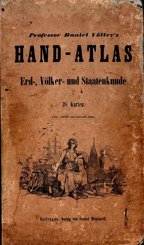
I am also a book collector on my spare time. I specialise in maps and atlases, and I do keep them all organised in a catalogue. Not that I need to, because I know exactly where each one is at any given time. (My private collection is not at all as gargantuan as the one I am custodian of at work.) Still, it's not so much about finding the books on the shelves, as it's about discovering more about them. Extracting the basic bibliographic data, when and where each book is from, is not always as easy as it sounds.
Sometimes they don't print the printing year. In some cases, they just expected people to throw the map away and buy a new one after New Year's. Others did not print the date so they could keep selling it for years, without letting customers know it was already outdated.
So now, decades later, people like me must resort to carefully checking the ever-changing borders and place-names. Russian Alaska, Austro-Hungary, East Germany and so on. In most cases, this can be pinpointed down to a three or four year period. (And to be honest, it's quite fun.) The greatest challenge still is extracting the publisher's name and other facts from foreign script books like Arabic and Chinese. But with the help of transcription tables, foreign friends and international library databases, these exotic riddles are normally solved in the end. Obsolete languages are a bit harder. I'm still working‒or rather looking for help‒on pre-war Japanese and Ottoman Turkish title pages that I'm not sure today's average native speaker could just sit down and read.
But the most difficult one this far was, believe it or not, a German world atlas.
German isn't some obscure language from ages ago, it's practically the same as my native tongue Norwegian. Compared to Chinese it is, anyway. And, no surprise, Germany is, from a professional cataloger's point of view, heaven on Earth. In fact, I use a German search engine, the Karlsruhe catalogue, to access worldwide library inventories. It has such a neat, concise interface, and everything is there, exactly in its right place. That's why I was so surprised when I tried to look up my latest acquisition.
I picked up this marvellous old atlas in a Zürich second-hand-everything-store. (It was either this book, a Moon globe or a genuine Napoleon style hat, and every night I pray that I won't be faced with such a heart-breaking dilemma ever again.) In the end, I don't regret my choice. The title is clear enough, the author as well. It's called

Professor Daniel Völter's Hand-Atlas der Erd-, Völker- und Staatenkunde
in 38 Karten. Vierte, vermehrte und verbesserte Auflage.
(Professor Daniel Völter's Hand Atlas of Geography, Ethnography and Nations
comprising 38 Maps. Fourth, extended and improved edition.)

Hand-Atlas (literally hand atlas) is German for a "home atlas", an atlas you keep at hand, as opposed to the Schul-Atlas designed for education and accompanied by a second volume text book.
This one was printed by Verlag von Conrad Weychardt in the small town of Esslingen near Stuttgart. There is no printing year, but each map sheet is dated with its latest revision. These range from 1853 to 1863. Among the latest is the map of the US, which was at the time a rapidly changing nation at war with itself. The book is beautifully printed, very fine-lined for its time and with several inset maps showing special areas of interest, elevations or demographics. The sheets total 38 hand-coloured maps of continents, nations and various commercial and natural aspects of the known world. It is truly as much a piece of art as a reference work, as well as a historical document.
I was especially curious to find out exactly when it was published, what with the varying dates on each page. But oddly, the book was nowhere to be found in any catalogues or databases. Even the German ones.
I considered the possibility that the maps were printed individually or as booklets, and issued to subscribers. This was often the case with larger works at this time, and as such it could have dodged the bibliographies. But a ten year period seemed a bit unlikely. And the book has an original printer's binding, not the private binding that is so typical of these "partial" issues. It seems to have been published collected as one piece, composed of accumulated sheets drawn from storage, in or shortly after 1863.

Africa in 1856, the same year David Livingstone completed the first trans-African journey by a white man. Most of the place-names of the interior are hearsay or guesswork. Note also the complete lack of information about the central rainforest areas.
After searching absolutely every catalogue I could think of, I found only two entries for this title: The Bayerische Staatsbibliothek had an 1855 edition and the Universitätsbibliothek Bern had a fifth edition dated 1867. The 1855 edition was listed in several German publishing lists of the time, but I found none later than 1860. That is exceptionally few surviving copies, and mine was clearly none of these.
On the commercial market, all I found was a British antiquarian bookseller offering one map sheet from this book, the East Asia map. There was no information on which edition it came from.
I also found a few other books by professor Völter. He had published an historical atlas in the 1850s and a school atlas in several editions. But my book was still mysteriously missing from all lists.

Alaska was a Russian colony until the Americans simply bought it in 1867. At the time everybody was outraged at Secretary of State William Seward for spending $7 million on something like that. But just imagine a Cold War with this lineup.
Still: If you look everywhere, you will inevitably find something. Jürgen Espenhort's book Petermann's Planet seemed to be the authoritative work on the subject. It contains a bibliography of German Hand-Atlases from 1800 to 1950. According to the index it included the Völter publications. I lent the book from Germany through the National Library of Norway, and after waiting a few weeks I could finally look up Professor Völter to find a sizeable piece about his life and career. (He was born in 1814, a priest-turned-geographer.)
The book also contained a meticulous list of his geographical publications. The list appears to be assembled from library catalogues, any authoritative list by Völter or his publishers are probably lost.
Espenhorst's impressive bibliography lists a 4th edition of the Hand-Atlas published in 1855 (apparently, there are four known copies worldwide, with only one privately owned‒Frankly, that's hard to believe), and a 5th edition printed in 1867. Again according to Espenhorst, no copies of this fifth edition could be located. (Although the University Library of Bern lists one in their catalogue, I haven't checked if it's physically there.) There is no mention whatsoever of a revised fourth edition published between these two.
Finally, Espenhort's book contains a facsimile of sheet no. 18 (the Switzerland map) from the 4th edition. This differs in several ways from the same sheet in my atlas, which I must assume then is a revised edition of the four copies found in German and Swiss libraries.
So, from what I can tell I am the owner of a (previously) unknown, undocumented book. Quite exciting. I tried contacting Mister Espenhorst, who requests updates, but the email address given in his book was defunct. So what to do? I post the full story here, hoping that some day somebody else will be frantically googling the old professor Völter (also spelled Voelter) just like I did, and that the revised fourth edition will in the end make its way onto the record somewhere. (Worst case, I'll have to will it to a public institution so that they have to index it.)

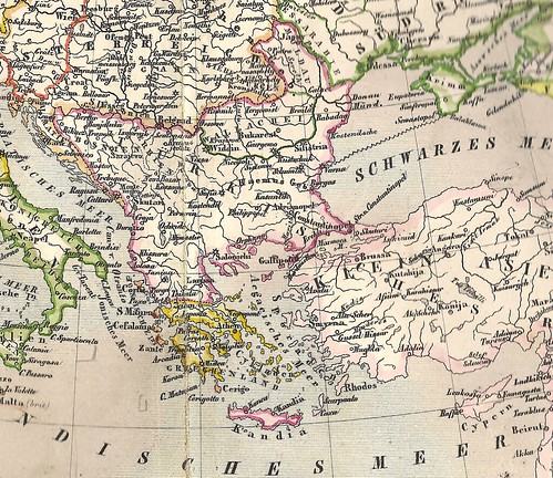
Until the 1870s, Turkey extended all the way to the Austrian border. The 300 years of Turkish presence is still evident in many aspects of Balkan culture.
To back it up and spread the word, I'll include the full atlas in PDF format here (I'm sorry the resolution isn't all it should be, but I don't have a wide selection of scanners in size A3 and upwards).
So please enjoy this old treasure‒It's truly one of a kind.
